Buy now by clicking "Add to Cart"
|
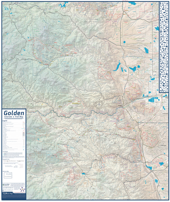
Golden Trail Map Print
Measures 38" x 32”
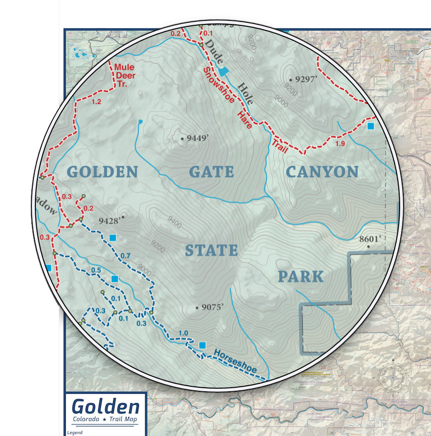
We took everything that is great about our folded Golden Trail Map and combined the front & back to one full page. What is better then expensive art? A map! What is the best type of map? A trail map of course! :) Hang it in your house, office, or garage! A unique cartographic print. Details: • 38” x 32” (height, width) • Updated regularly • Includes new trails like Floyd Hill & Rocky Flats. • Printed on high quality paper. Displays: • Trails (Multi-Use & Hiking only) • Paved Bike Paths • Roads • Public Land Boundaries (Jeffco Open Space, USFS, etc...) • Hydrography • Detailed Contour Lines & Much More! Boundaries: North • Eldorado Springs South • Chatfield High School East • Bear Creek Lake Park West • Peak to Peak Highway A must have map for any outdoor enthusiast in the Denver Metro! |
Includes:
Communities like Golden, Arvada, Lakewood, Littleton, Morrision, Evergreen, Kittredge, Idledale, Indian Hills, Genesee, Black Hawk, Central City, Rollinsville, Pinecliffe, Wondervu, Eldorado Springs.
Communities like Golden, Arvada, Lakewood, Littleton, Morrision, Evergreen, Kittredge, Idledale, Indian Hills, Genesee, Black Hawk, Central City, Rollinsville, Pinecliffe, Wondervu, Eldorado Springs.
Open Space & Public Lands like Eldorado Canyon State Park, Rocky Flats National Wildlife Refuge, White Ranch Open Space, Golden Gate Canyon State Park, Arapaho National Forest, Mount Galbraith, North Table Mountain, South Table Mountain, Lookout Mountain, Apex Park, Genesee Park, Elk Meadow Park, Alderfer Three Sisters Park, Lair O' the Bear, Matthews Winters Park, Red Rocks, Green Mountain (William F. Hayden), Bear Creek Lake Park, Mount Falcon Park, Denver Mountain Parks, Clear Creek County Open Space.
Questions? Please scroll down to FAQs
|
Detailed
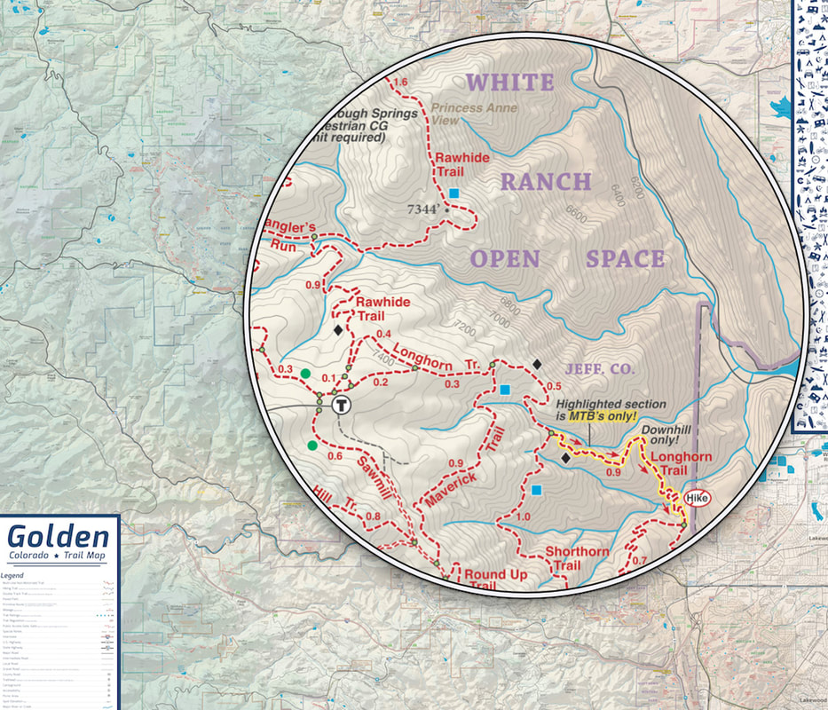
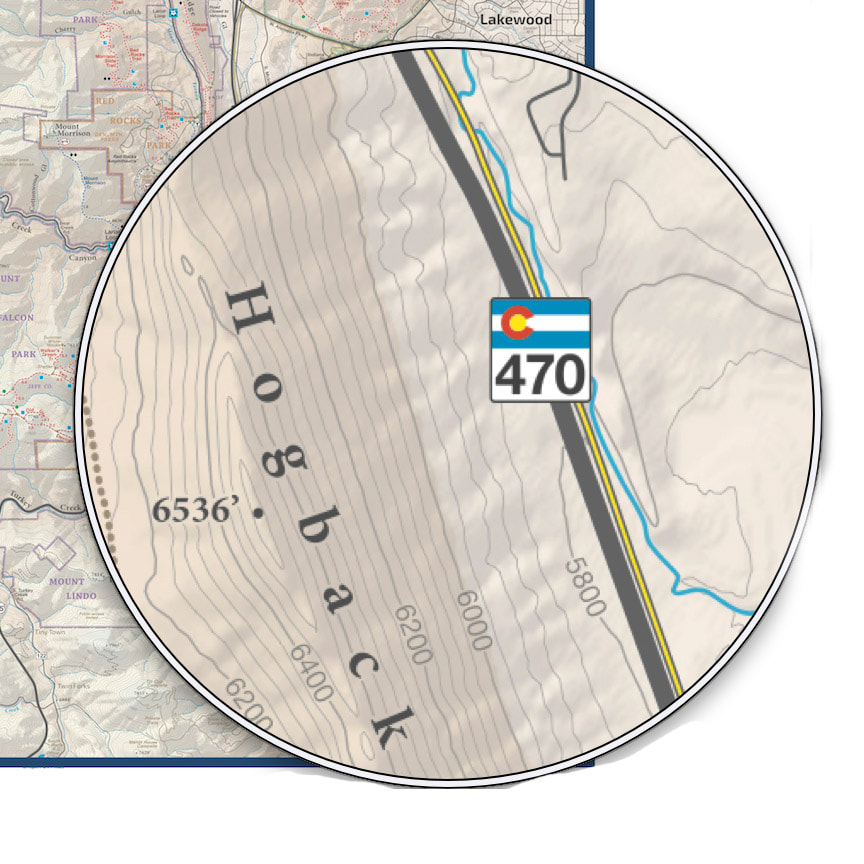
Detailed Contour Lines & Hypsometric Shaded Relief
Mounted on Gator Board
ADD MORE INFO HERE........... |
Trails are colored for different user types
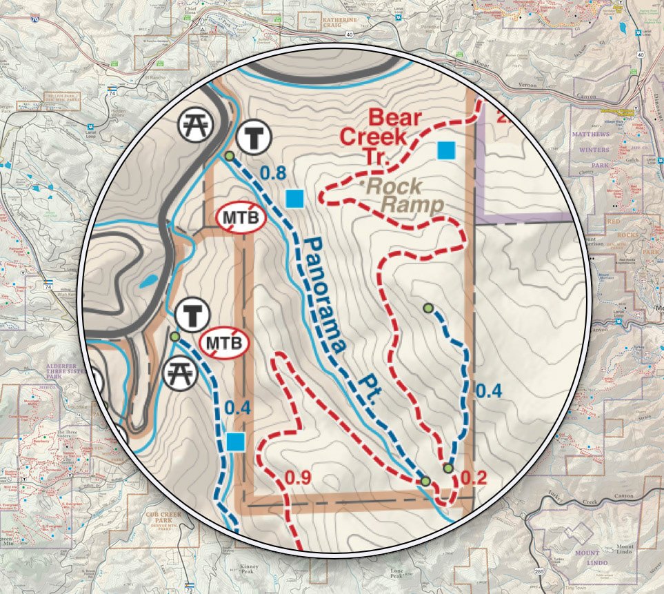
Public Lands
Framed
ADD MORE INFO HERE...... |
FAQs
Why does this map cost so much?
Printing a map at this size in full color at high resolution is expensive. Lamination is also expensive. This map in printed in limited quantities.
What type of material is the map printed on?
The map is printed on quality stock paper and then laminated. Lamination enhances the map colors and protects the map from UV rays. Lamination also makes the map tear tough.
Do you offer the map framed?
Framed maps are available as a special order. But because of the large map size it is expensive. This map framed looks awesome and makes for a museum style display piece. You can see a larger framed version of this map at Wheat Ridge Cyclery …go check it out! Please contact us for more info and a price quote on framing.
How is the map shipped?
The map is shipped rolled in a large tube. Standard shipping is via USPS for $20 . Depending on stock expedited shipping is available at an additional cost. Please contact us before purchase for more information.
Why is the deliver date at the least 1 week from the day I ordered?
Because of the size of this map we have to print them in limited quantities. After printing, the map is laminated. The 1 week delivery timeframe is to give me enough time to get the map to you as a quality piece in good condition.
Can I see this map in person before I buy it?
A larger version (but with less detail) is on display at Wheat Ridge Cyclery (map). Stop in and check it out! (The Wheat Ridge Cyclery map is printed at 56x72" - this map is 44x54")
Why does the larger Wheat Ridge Cyclery map have less detail?
I knew you'd ask that ;) The WRC map was printed in the Spring of 2012 and before making this map available to the public I have added more detail to the hydrography (streams) and city / town elevations.
What sets this map apart from others?
I love the Colorado Rocky Mountains and this map was a true labor of love (see About the Cartographer). This map is unique because it is printed at a very large size and detailed scale, giving map readers a better understanding of the geography that shapes the Colorado Rocky Mountains. This is the first map of Colorado available at retail that includes high resolution National Land Cover Data from the USGS, displaying a true representation of the physical landscape.
I thought Singletrack Maps only made trail maps, why this map?
I am a professional Cartographer and create all kinds of maps. But I created this map because the Colorado Rocky Mountains are awesome!
Why should I buy this map?
You should buy this map because like me you probably LOVE MAPS! Put this map in your office, home, garage, wherever! People gravitate to maps and they make a great center piece to any conversation or story. I'd bet the most often question you get is "Where did you get that map?" :)
What stores sell this map?
This map is only available directly from Singletrack Maps online.
Can I order online with a Credit Card?
Yes. We use PayPal. You do NOT need a PayPal account to order through PayPal.


|

|
© 2023 Singletrack Maps, LLC • All Rights Reserved.